
Export your survey to DXF and ready-to-deliver sheets
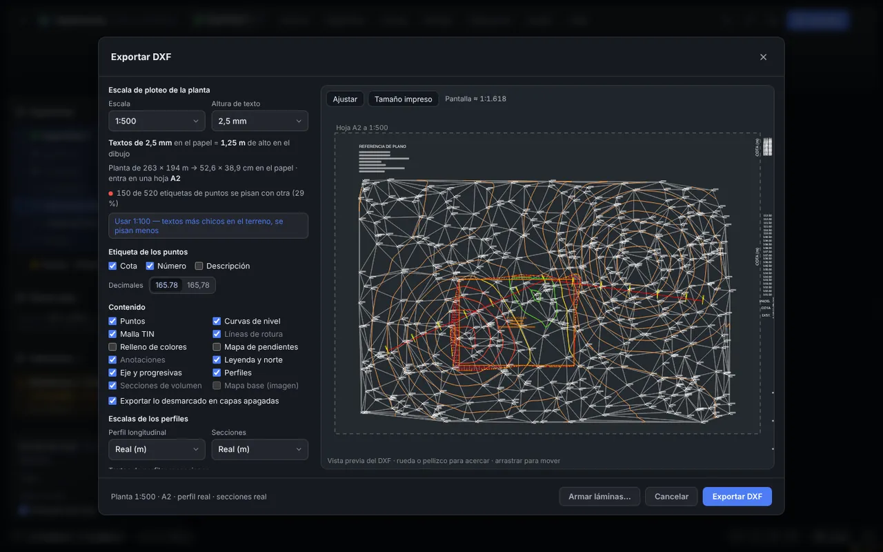
Before exporting you see a preview of how it will look in CAD, with the chosen sheet and plot scale, so text stays readable and does not overlap.
Developed by 
What it includes
Preview and plot scale
Scales from 1:100 to 1:5000; text and symbols come out at the size you asked for on paper.
Organized layers
ISO 13567-style naming: C-TOPO-CNIV-MAES, C-TOPO-PNTO, C-PLON-TERR… easy to switch off or filter in CAD.
Delivery sheets
A0 to A4 sheets, landscape or portrait, margins, a title block with your details and logo, a legend and automatic scales.
Direct PDF
A vector PDF downloaded without going through a printer, also on iPhone and iPad.
Base map and reference drawings
Include the base map as a georeferenced image (downloaded in a ZIP with the DXF) and reference DXF drawings underneath.
Annotations
Dimensions, levels, slopes, monuments and areas drawn on the map go to the DXF on their own layers.
How it works
- Open the export dialog and choose the plot scale.
- Select what to include and check the preview.
- Export the DXF or build the sheets.
- Download the PDF or the DXF in millimetres to print at 1:1.
FAQ
Which programs open the DXF?
AutoCAD, BricsCAD, LibreCAD and any program that reads DXF files.
Is what I uncheck also exported?
Yes, on layers that are switched off, so you can turn them on in CAD if needed.
You may also like
Contour line generator from survey points
Upload the points file from your survey and get contour lines in seconds, on a TIN mesh you can fix by hand so the terrain looks the way it really is.
Learn more →Longitudinal profile and cross sections
Draw the alignment on the map and the ground is interpolated from the TIN mesh. The profile and sections update as you move the alignment.
Learn more →Cut and fill volume calculator
Compare the existing ground against a level, a pad or a design surface and get cut, fill and the material to haul away or bring in, with a report ready to deliver.
Learn more →Try it with your own points
It runs in your browser: no account, nothing to install.
Open the free app